John Frost, Chartist, Newport[1] John Frost's Birthplace, Royal Oak, Newport
[2] John Frost's Will
[3] John Frost's Grave,Horfield, Bristol
[3.1] Star of Gwent (1877):John Frost subscription appeal; obituary notice
[4] The Chartist Caves, Llangynidr Mountain (Trefil Las)
[5] The Chartist rally on Kennington Common in April 1848
~~~~~
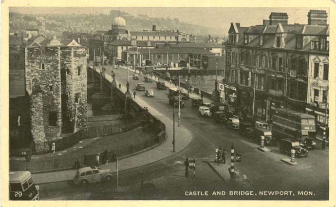
[1] John Frost's Birthplace, Royal Oak, Newport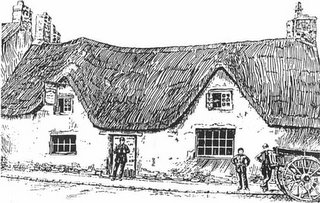 The Royal Oak, Newport: birthplace of John Frost, Chartist
John Frost: The most famous of all those transported to Australia, Frost had been mayor of Newport and was a serving magistrate when he became involved in the Chartist movement. After chairing the first Chartist Convention, during which time he was sacked by the Home Secretary as a justice of the peace, Frost returned to Wales where he became involved in the conspiracy that was to lead to the Newport Rebellion.. Many historians doubt that Frost was the true leader of this violent rising, not least because he had always advocated the use of moral force; nevertheless, he stood by his comrades once the decision to proceed was made, and was prominent in the event. Frost was born at Newport on 25 May 1789, the son of John and Sarah Frost, who kept
the Royal Oak tavern in Mill Street. He became a prosperous woollen draper, and married Mary Geach, a widow, with whom he had five daughters and two sons. His early politics were those of a Cobdenite Radical
Source
here:
Transported to Australia
CHARTIST ANCESTORS
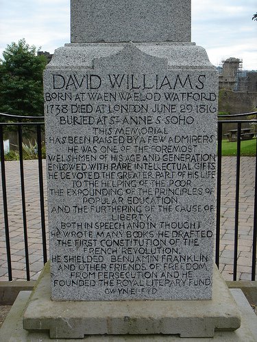
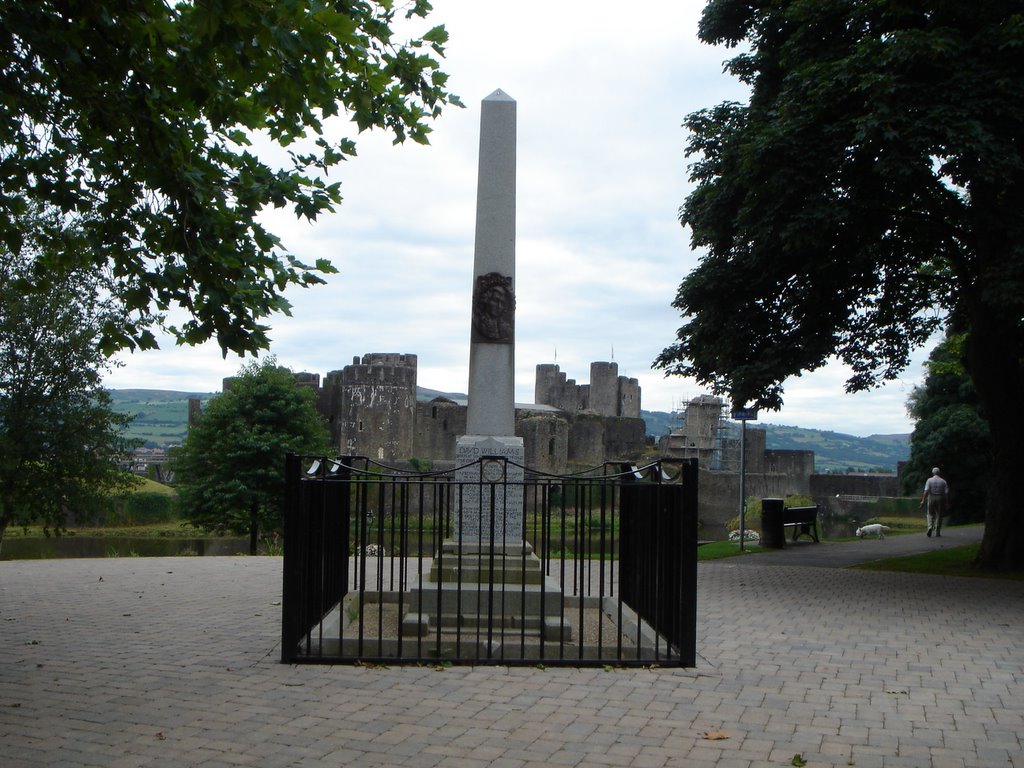
[2] John Frost's WillJohn Frost's Will John Frost of Stapleton, Glos late of Newport, Mon 1874.
Anne Frost - sole executrix - John H Clarke - Commissioner
This is the last will and testament of me John Frost of Stapleton in the County of Gloucester. I give the whole of my real and personal estate and effects of whatever nature and kind soever to my daughter Ann Frost in trust for the following purposes. The property which I am now possesses of consists of a lease of the house in High Street Newport occupied by Mrs Tadd.
The Royal Oak which was formerly a freehold estate but is now sold to the tenant Mr Watkin Jones on the following conditions for the sum of fifteen hundred pounds: Three hundred pounds to be paid on hand which sum I have received: Twelve hundred pounds to remain on the premises for which I have a mortgage on the premises, interest to be paid on the sum at the rate of 4½ per cent, now the debt to be reduced by the payment by Mr Jones to me of one hundred a year, the interest to be diminished as the payments are made, but Mr Jones has not fulfilled this part of the contract, I have received from him the sum of £50 only. This property to be divided between my daughter Catherine Frost now in Tasmania, Ellen Davies my daughter and Anne Frost my daughter now living with me at Stapleton in equal parts. I direct that my books be sold and the proceeds divided between my daughters Catherine, Ellen and Anne in equal portions, the household furniture I give to my daughter Anne for her sole and separate use without any reservations. I again say this is my last will and testament and I appoint my daughter Anne as my executrix solely. I desire that my funeral be a public one and that I be buried by the side of my wife and son in Horfield Churchyard. I give to my grand daughter Fanny my ring which formerly belonged to her mother, my daughter Anne knows what my intentions are respecting my friend Mr Charles Groves.
Signed, sealed, published and declared by the said testator John Frost who in his presence and at his request have subscribed our names as witnesses thereto this 12th day of April 1874. John Frost
Witnesses James Street; William Thomas;
Proved at Bristol the ninth day of January 1878 by the oath of Anne Frost, spinster, (daughter of the deceased) the sole executrix to whom administration was granted.
The testator John Frost was late of Stapleton in the County of Glouster, Gentleman and died the twenty seventh day of July at Stapleton aforesaid.
Under £1500
Robert Graham, Solicitor, Newport, Mon.
Certified to be an examined copy
Source
here:
Newport Past[3] John Frost's Grave,Horfield, Bristol
"The outward mark of respect paid to men merely because they are rich and powerful... hath no communication with the heart"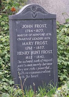 John Frost's grave, Horfield, Bristol.
 Source
here+ See also:
Newport past-
photo of Frost grave [ source of above?]
http://www.newportpast.com/nfs/strands/frost/grave.jpg
photo of churchyard
http://www.newportpast.com/nfs/strands/frost/church.jpg
From Newport Past website:
John Frost's Final Resting Place
Richard Frame tells how he 'tracked down' John Frost's final resting place and obtained a grant from Newport Council for a new headstone:
"For a long time I searched for the grave of John Frost. I couldn't believe that no one in Newport knew where this famous son had been laid to rest. I finally got the information from a copy of his will in Newport reference library (see a transcription). Here it said he wanted to be buried with his son and wife at Horfield Parish Church in Bristol.
After searching the graveyard for hours I found no sign of a stone. As I was leaving, the vicar approached me with a book which he told me was a plan of the site made in 1939 by the sexton showing each memorial. Here I found the name Henry Hunt Frost, John's son. I went to the spot and found a stone disappearing into the ground with the word Henry on it. In the ground we found the other bits indicating it was indeed the Frost grave.
I approached Newport Council who gave me a small grant for a headstone and Les (Tombstone) Thomas carried out the task and created a beautiful stone. Neil Kinnock unveiled the stone and it was recorded by the BBC who interviewed me."
Source:
http://freepages.genealogy.rootsweb.com/~monfamilies/Frost%20John%20of%20Newport.htm
John Frost of Stapleton, Glos late of Newport, Mon 1874.
Anne Frost – sole executrix – John H Clarke – Commissioner
This is the last will and testament of me John Frost of Stapleton in the County of Gloucester. I give the whole of my real and personal estate and effects of whatever nature and kind soever to my daughter Ann Frost in trust for the following purposes. The property which I am now possesses of consists of a lease of the house in High Street Newport occupied by Mrs Tadd. The Royal Oak which was formerly a freehold estate but is now sold to the tenant Mr Watkin Jones on the following conditions for the sum of fifteen hundred pounds: Three hundred pounds to be paid on hand which sum I have received: Twelve hundred pounds to remain on the premises for which I have a mortgage on the premises, interest to be paid on the sum at the rate of 4½ per cent, now the debt to be reduced by the payment by Mr Jones to me of one hundred a year, the interest to be diminished as the payments are made, but Mr Jones has not fulfilled this part of the contract, I have received from him the sum of £50 only. This property to be divided between my daughter Catherine Frost now in Tasmania, Ellen Davies my daughter and Anne Frost my daughter now living with me at Stapleton in equal parts. I direct that my books be sold and the proceeds divided between my daughters Catherine, Ellen and Anne in equal portions, the household furniture I give to my daughter Anne for her sole and separate use without any reservations. I again say this is my last will and testament and I appoint my daughter Anne as my executrix solely. I desire that my funeral be a public one and that I be buried by the side of my wife and son in Horfield Churchyard. I give to my grand daughter Fanny my ring which formerly belonged to her mother, my daughter Anne knows what my intentions are respecting my friend Mr Charles Groves.
Signed, sealed, published and declared by the said testator John Frost who in his presence and at his request have subscribed our names as witnesses thereto this 12th day of April 1874. John Frost
Witnesses James Street; William Thomas;
Proved at Bristol the ninth day of January 1878 by the oath of Anne Frost, spinster, (daughter of the deceased) the sole executrix to whom administration was granted.
The testator John Frost was late of Stapleton in the County of Glouster, Gentleman and died the twenty seventh day of July at Stapleton aforesaid.
Under £1500
Robert Graham, Solicitor, Newport, Mon.
Certified to be an examined copy
Transcribed from a photocopy by Dave Woolven, 2 Aspen Way, Malpas Park, Newport, South Wales. NP20 6LB Tel 01633 858 359 22 February 2001
[3.1] Star of Gwent (1877):John Frost subscription appeal; obituary noticeStar of Gwent
17th March, 1877
Frost the ChartistSir Edward Watkin is engaged in promoting a subscription on behalf of Mr. John Frost; the well known Welsh Chartist, who was sentenced to death in 1839 through his participation in the rising at Newport. Mr. Frost is 93 years of age and still lives in the neighbourhood of Bristol. It is somewhat singular that the jury, judge, and counsel engaged in his prosecution, thirty eight years ago, are all dead. His sentence was commuted to one of transportation for life, and he was sent to Van Diemen's Land. He lived through it all, and when the amnesty was granted to political prisoners at the close of the Crimean War, he was able to return to his native country.
Mr. Frost was a Justice of the Peace, had been Mayor, and was a successful tradesman in Newport at the time of the Chartist Rising. He very ardently, but not very wisely, espoused their cause and lost both property and liberty for what he conceived to be his patriotic duty.
He is in fair health now, but his memory at times somewhat wanders. He lives with his daughter who has attended his declining years with affectionate care and solicitude. Sir Edward Watkin hearing of his position, voluntarily sent his family £20 a few days ago, and he is now engaged in the benevolent work of trying to raise £200 or £300 to solace the old Chartist's exile in the days of proper forgetfulness.
Source
here
Star of Gwent
29th July 1877
Death of John FrostWe understand that Mr. John Frost, the old Chartist, died at his daughter's home in Stapleton, Bristol on 27th inst. at the ripe old age of 93.
Mr. John Frost, prior to the lamentable outbreak in which he was the prime leader, commenced business in Newport as a tailor and draper in 1811, in a house belonging to his step-father, near the Royal Oak, Mill Street. Shortly after this he married a widow named Geach, who, with her two children, resided with her uncle, Mr. William Foster, a member of the old Corporation and Mayor of the Borough in the years 1804, 1812 and 1817. At Mr. Foster's demise Mrs. Frost and her children derived a handsome property. By Mr. Frost, she became the mother of two sons and five daughters. About the year 1822 Mr. Frost first displayed aspirations to rank as a public writer, and pamphleteering was a favourite mode of showing his hostility.
Mr. Frost was an early convert to the cause of the Chartists. His earnest advocacy and strong expression of language soon got him into trouble. His prosecution for libel and committal to prison tended to increase his popularity and brought him more into public favour. He was elected one of the Council of the Borough at the close of 1835 and was recommended to the King, by the Secretary of State for the Home Department, for appointment as one of the Justices of the Peace for the Borough. He is said to have performed the duties with diligence, zeal, independence and impartiality. In 1837 he was elected to fill the civic chair, and during his year of office as Mayor, acted with becoming dignity. He subsequently became so extreme in his political views, and so violent in his language that the attention of the authorities was called to the matter, the result being that Mr. Frost's name was obliterated from the list of Justices of the Peace. From thereon his life is a matter of history, made poignant by the utter futility of the enterprise in which he participated.
Source
here
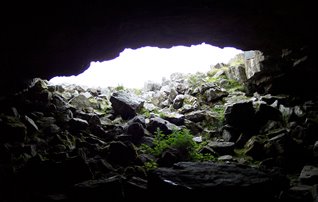
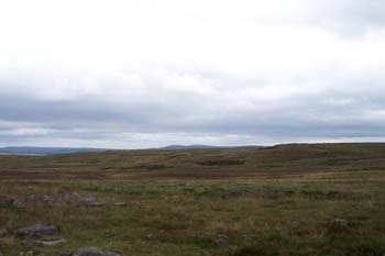
[4] The Chartist Caves, Llangynidr Mountain (Trefil Las)
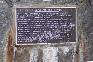

 The Chartist Caves, Llangynidr Mountain (Trefil Las)
SO 12771 15230 ( N51 49 46.9 W3 15 56.7
Source
here and
here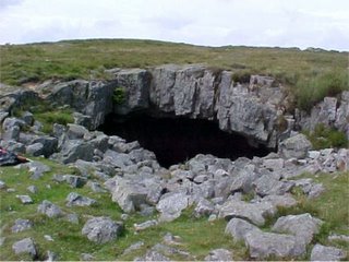
Chartist Cave, Mynydd Llangynidr- source
hereblaenau-gwent.gov.uk
The following excerpt covers Chartist organisation in the Monmouthshire Valleys, with reference to mass demonstrations, arms manufacture and the Chartist Cave::
Increasingly worried by the rise in Chartist numbers, the local ironmasters and clergy organised an anti-Chartist meeting at Coalbrookvale for April 29th. Crawshay Bailey was in the chair and George Brewer (owner of the Coalbrookvale Ironworks) and John Brown (Cwmcelyn and Blaina Ironworks) also attended. Bailey made an impassioned speech attacking the Chartists, finishing defiantly: "I owe all that I have to my own industry and I would risk my life rather than lose my property".
The answer came two days later when a huge rally gathered on the Star Field, Dukestown (now the Twyn Star Housing Estate) with almost 5,000 people in attendance. Bands played and banners fluttered, the chief speakers arrived in a four-wheeled chaise decorated with flags. Tension increased when Capel Hanbury Leigh, Crawshay Bailey and Thomas Powell all agreed to refuse employment at their works to known Chartists, and furthermore the Royal Oak at Coalbrookvale was declared out of bounds to all of Bailey's employees.
Then, on May 9th, Vincent, Edwards and others were arrested and taken to Newport. A riot broke out, and the men were subsequently imprisoned at Monmouth Gaol. On Whit Monday, May 20th, 30,000 people attended a huge rally at Blackwood and a petition was set up for Vincent's release. Another rally at Coalbrookvale on July 1st attracted a crowd of 10,000 and by July 12th, when a petition was presented to Parliament, over a million signatures had been gathered. The petition was rejected.
Chartists had always fallen into two camps - the "moral force" men (of whom Zephaniah Williams was one) and the "physical force" men - those prepared to take up arms to gain the Charter. With the failure of the petition the physical force faction gained the upper hand. On August 12th, the largest gathering of the whole of the 19th Century took place when the Chartists met at the Star Field, Dukestown, when over 40,000 attended.
By now, Chartists were beginning to arm themselves - pikes were being made at the smithy at the Victoria Works, Ebbw Vale, and at the Chartist Cave on Mynydd Llangynidr above Trefil (after the Rising, the authorities discovered a small hearth with bellows, iron and coal).
In Tredegar, John Rees (Jack the Fifer), David Jones (Dai the Tinker) and Isaac Tippings (the Tailor from Nantyglo) were very active around the lodges. The "Chartist Lights", lanterns and torches moving across the mountains, were seen and hardly a night went by without fiery speeches and illegal gatherings.
Typical wanted poster at this time
On August 26th, the Chartist Convention was reconvened and, on September 14th, the date was decided upon for a co-ordinated Uprising. Major Beniowski (a Polish emigré) was sent to Wales to co-ordinate preparations and although he may have been a type of mercenary we know little of him and his precise role is unclear.
September and October saw Blaenau Gwent as a hive of frantic activity. On October 3rd, some 500 people attended a meeting at the Royal Oak, Coalbrookvale, where John Frost urged restraint until the rest of Britain was ready to rise. At a secret meeting later that night, Frost asked Zephaniah Williams, William Jones and David Lewis (of the King Crispin) "Will you rise at my bidding, for it must be done?” Attempts were made to induce soldiers at Brecon and Newport to desert. Plans were made (and changed) but finally it was decided to march on Newport on the night of Sunday, November 3rd. Meanwhile, the production of arms intensified and more and more people joined the Chartist lodges. Evan Edwards, the Tredegar clockmaker and James Godwin, the mason from Brynmawr, were busy making bullets, while puddlers and colliers at Blaina ordered their muskets.
The plan was for the Chartist forces from all over Monmouthshire to meet at Risca before marching on Newport. On Saturday, November 2nd, at a meeting at the Royal Oak, Coalbrookvale, Zephaniah Williams and Thomas Guttery (of Blaina) made speeches and told the men gathered there to meet, armed, on the following evening. According to Benjamin James, a local collier, a few people entered backroom where Thomas Ferriday and others were seen handling guns. A similar gathering was in full swing at the King Crispin in Brynmawr, with Ishmael Evans in the chair, where David Lewis and his men were taking oaths of secrecy on a large Bible.
On the morning of Sunday, November 3rd, about 200 people gathered at the Royal Oak and were told to meet in the evening and to bring their weapons and food. Zephaniah Williams said to them that if the soldiers fired they were "to do their best". At 6 p.m., they set off for Mynydd Carn y Cefn where Zephaniah stood under an umbrella on a large mound by the roadside. A horn was sounded and guns tested.
By 8 o'clock, almost 4,000 men had gathered waiting for the men from Dukestown, Brynmawr, and Beaufort. Among the Nantyglo contingent was Abraham Thomas, one of William Davies's "platoon" of ten men. Despite his wife's desperate pleas, he had left home at about 7 o'clock. Wrapping her youngest child in a shawl, she ran after him through the torrential rain to the Royal Oak where Zephaniah's wife told her that he had already gone to the mountain. Less than fifteen hours later Abraham Thomas lay dead outside the Westgate Hotel.
At Rassau, David Howell, William David, John Jones, William Williams and 50 others were gathering their men, some by force. At 8 p.m. they stopped outside Carmel Chapel and required the congregation to follow them to Newport. At 11 p.m., they broke into the Beaufort Arms, at Beaufort Rise, demanding ale and killing the landlord's dog (the landlord was an anti-Chartist and had already fled).
In Tredegar and Sirhowy, the Red Lion at Colliers Row and the Colliers Arms in Park Row had been turned into pike factories. Jack Rees (the Fifer) accompanied by William Evans, Thomas Morgan and John Morgan led the Tredegar men down the Sirhowy valley to meet Frost at Blackwood. At Twyn y Star, hundreds had gathered led by Rees Meredith (one of those killed) and Dai the Tinker (David Jones) - in his velvet jacket and spotted neckerchief. At about 8 p.m. they met the men of Benjamin Richards' Star Inn lodge at Sirhowy Bridge before moving off to meet Zephaniah Williams and his men at Mynydd Carn y Cefn. Passing through Ebbw Vale they met up with 2,000 at the Pen y Cae ironworks, and about 20 of them pushed their way into the Lamb Inn demanding more beer. Later, another gang arrived dragging the landlord of the Wyvern Inn, Sirhowy along with them. At about 9 p.m., all the contingents met near the Harfords' residence and then moved off down the valley towards Newport. After much delay (caused mainly by the appalling weather and by calling off at pubs on the way!) the Heads of the Valleys contingent met up with Frost's forces at the Welsh Oak, Risca at about 6.30 a.m.
(...)
+ Source
here+ Note: the above text is based on this text
hereblaenau-gwent.gov.uk
The Blaenau Gwent Chartists
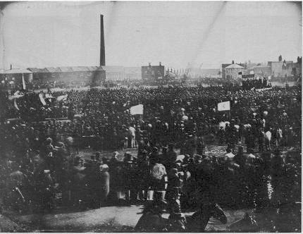
Guide to the Chartist Cave here[5] The Chartist rally on Kennington Common in April 1848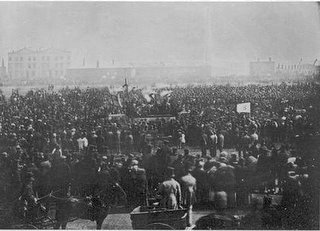 The Chartist rally on Kennington Common in April 1848 that marked the last high tide of Chartism as a mass movement.
Source:
CHARTIST ANCESTORS
http://chartists.net/What did your family do in the revolution?Millions signed the three great Chartist petitions of 1839 to 1848. Thousands were active in those years in the campaign to win the vote, secret ballots, and other democratic rights that we now take for granted.
Chartist Ancestors lists many of those who risked their freedom, and sometimes their lives, because of their participation in the Chartist cause. The names included on the site are drawn from newspapers, court records and books of the time, from later histories and other sources.
I would like to thank the many historians, researchers and the descendents of those associated with Chartism who have helped with this site since it was launched in 2003.
Mark Crail Source
hereSee also vauxhallsociety.org.uk
here for photo's and information on Kennington Park:
Kennington Park was formerly Kennington Common and consists of approximately 20 acres which is still part of the Duchy of Cornwall but is managed by Lambeth Borough Council. From the earliest recorded times the Common was widely used for fairs and gatherings of allsorts. Preachers including both Wesley and Whitefield held services on the Common to very large audiences sometimes as many as 50,000 gathered to hear their sermons.
In 1848 the Chartists held a meeting there and though the Duke of Wellington called in hundreds of police the meeting ended quietly. The park lodge, known as the Prince Consort's Model Lodge was designed by Henry Roberts.
Camberwell New Road was built in 1818 splitting the Common in two. The southern part, where the Surrey Gallows used to be erected became the site of St Mark's Church built in 1822. Interestingly Parliament only passed the Act to use the common land in this way was not passed until 1824, six days before consecration. The rest of the park was enclosed in 1825 but seems to have been badly managed as in 1852 Thomas Miller said 'Kennington Common is but a name for a small grassless square, surrounded with houses and poisoned by the stench of vitriol works and by black open sluggish ditches.'
Following the formation of the park locals could no longer play games of cricket and formed
the Oval Cricket Club which was leased to the Surrey Cricket Club for a nominal fee. In 1869 Doulton and Co donated a statue by George Tintworth - Pilgrimage of Life to the park.
See also interesting wikipedia discussion re Kenington Park, esp re enclosure following 1848 Chartist Demonstration
here:NOTES ON THE SOURCES OF INFORMATION ON KENNINGTON PARK
* Introduction: I was living right next to Kennington Park for eight years fbefore I started to realise it had an interesting history. Much of my information was gathered in an informal way rather through scholarly research (although I have now done a PhD) so exact or authoritative references are difficult to give on all points. However some notes may help those interested in the quality of information offered here, especially as this is an issue for Wikipedia.
Another point is that I aimed to give a sense of the history by inferring things from context. e.g. William Blake lived nearby and being the person he was must surely have visited the spouting hole that the common was. Tom Paine visited Blake and we can imagine that with their interest in democracy Blake would have taken Paine to the speakers corner. This is conjecture but it immediately gives a clearer sense of what was going on at the common (at least for those who know anything about Blake or Paine!)
Having said this much research needs to be done and I see this timeline a pointer for researchers rather than the last word summary of decades of scholarly work.
* The Chartists: The Chartist 'monster rally' of 10th April 1848 is what I'd call an incontravertible fact.
The idea that the common was enclosed in response to that event was something that occured to me like a light going on in my head whilst immersed in this part of the research. It is my interpretation and seems very likely to be true rather than an incontravertible fact.
What is more certain is that historians have tended to represent the Chartists as a failure with 10th April 1848. Again I think that this is due to their vested interests rather than anything of a factual nature. See Dorothy Thompson's work for a more sympathetic approach.
According to her there is still no authoritative overview of Chartism. This is partly due to the fact that Chartism was a federation of small groups widely spread and partly the above mentioned bias against working class self activity.
The tired old case for Chartism as a failure can be found in "Failed Chartist Demonstration in London' History Today Vol 48 issue 4 pp 34/35 1998
* Cricket history. Details were taken from the web and have not been verified in archives. Note how the formation of the SCCC happened in time for cricket to be cleared from the common by the enclosure
~~~~~
vauxhallandkennington.org.uk
KENNINGTON PARK
The Birthplace of People's Democracy
Based mainly on a pamphlet by Stefan Szczelkun (1997)
A short one hundred and fifty years ago Kennington Common, later to
be renamed Kennington Park, was host to a historic gathering which
can now be seen as the birth of modern British democracy. In reaction
to this gathering, the great Chartist rally of 10th April 1848, the common
was forcibly enclosed and the Victorian Park was built to occupy the
site.
The significance of Kennington Park goes back to its origins as a
common. What is important about this site is not the physical aspects of
its layout but the traditions of its usage, a usage which arises from its
unique position in South London. It is here that the road from
Buckingham Palace to Dover crosses the older road from the City of
London to Portsmouth. It was the last common before the centres of
power to the north of the river, particularly Parliament. It was first
recorded as a common on Rocque's 1746 map of London, but it may
well have been crucial as a public meeting place long before that.
(...)
Source
here (pdf doc)